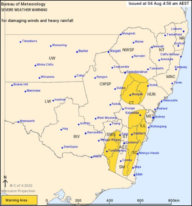
A Severe Weather Warning is in place for DAMAGING WINDS and HEAVY RAINFALL for people in the Illawarra, Southern Tablelands and parts of South Coast, Central Tablelands, Hunter, North West Slopes and Plains, Central West Slopes and Plains, South West Slopes, Snowy Mountains, Australian Capital Territory, Metropolitan and Riverina Forecast Districts.
A complex low pressure system moving across the Great Australian Bight and an associated trough and cold front are causing vigorous northwesterly winds across southeast NSW, as well as the potential for heavy rainfall from Thursday morning. This front will move offshore early Friday morning.
DAMAGING WIND GUSTS with peak gusts of around 90 km/h are possible over the ranges to the west of the ACT, as well as the eastern Great Dividing Range from Bombala to south of Crookwell, extending north to the Blue Mountains during Thursday morning.
DAMAGING WINDS, averaging 80 to 90 km/h with peak gusts in excess of 125 km/h are likely to continue for alpine areas above 1900m.
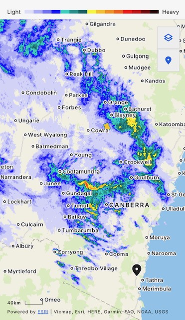
HEAVY RAINFALL which may lead to FLASH FLOODING are expected across the Snowy Mountains and the South Western Slopes. Six-hourly rainfall totals between 45 and 60 mm are expected, with localised falls up to 100 mm possible with embedded shower and thunderstorm activity that may occur over shorter time frames.
HEAVY RAINFALL which may lead to FLASH FLOODING are expected across the northern parts of the Central Tablelands from Thursday afternoon. Six-hourly rainfall totals between 20 and 40 mm are possible with localised higher falls up to around 60 mm with shower and thunderstorm activity.
Saturated soils in the Central Tablelands and Illawarra bring an increased risk of gusty winds toppling trees and powerlines.
A Flood Watch is current for Inland New South Wales Central and South West Catchments.
Locations which may be affected include Braidwood, Goulburn, Bombala, Tumbarumba, Tumut, Khancoban and Thredbo Top Station.
Thredbo recorded sustained winds of 85 km/hr at 11:12am Wednesday.
Khancoban recorded a wind gust of 100 km/h at 2:05am Thursday.
Cabramurra recorded a gust of 98 km/h at 12:17 am Thursday.
The State Emergency Service advises that people should:
* Move vehicles under cover or away from trees.
* Secure or put away loose items around your house, yard and balcony.
* Keep at least 8 metres away from fallen power lines or objects that may be energised, such as fences.
* Trees that have been damaged by fire are likely to be more unstable and more likely to fall.
* Report fallen power lines to either Ausgrid (131 388), Endeavour Energy (131 003), Essential Energy (132 080) or Evoenergy (131 093) as shown on your power bill.
* Don’t drive, ride or walk through flood water.
* Keep clear of creeks and storm drains.
* If you are trapped by flash flooding, seek refuge in the highest available place and ring 000 if you need rescue.
* Be aware that run-off from rainfall in fire affected areas may behave differently and be more rapid. It may also contain debris such as ash, soil, trees and rocks.
* After bushfires, heavy rain and the loss of foliage can make the ground soft and heavy, leading to a greater chance of landslides.
* Stay vigilant and monitor conditions. Note that the landscape may have changed following bushfires.
* For emergency help in floods and storms, ring your local SES Unit on 132 500.
Images: BOM